

INDIAN ARMED FORCES CHIEFS ON
OUR RELENTLESS AND FOCUSED PUBLISHING EFFORTS

SP Guide Publications puts forth a well compiled articulation of issues, pursuits and accomplishments of the Indian Army, over the years

I am confident that SP Guide Publications would continue to inform, inspire and influence.

My compliments to SP Guide Publications for informative and credible reportage on contemporary aerospace issues over the past six decades.
- Prime Minister witnesses 'Bharat Shakti' – a Tri-Services Firing and Manoeuvre Exercise in Pokhran, Rajasthan
- Interim Defence Budget 2024-25 — An Analysis
- Union Defence budget 2024
- Prime Minister Modi Commemorates Indian Navy Day in a Grand Ceremony
- Prime Minister Modi Flies in the LCA Tejas
- New Chapter in India-Italy Defence Ties
- Airpower beyond Boundaries
India's satellite-based networking capabilities
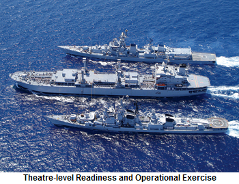
Rukmini will provide networking capabilities with various Indian Navy’s assets. During Theatre-level Readiness and Operational Exercise (TROPEX) in the Bay of Bengal in 2014, Rukmini was able to network about 60 ships and 75 aircraft seamlessly.
India launched its first dedicated defence satellite, GSAT-7, for the Indian Navy on August 30, 2013. GSAT-7 was successfully launched by the Ariane-5 launch vehicle of Arianespace from Kourou, French Guiana. Ariane-5 precisely placed GSAT-7 into the intended geosynchronous transfer orbit (GTO).
GSAT-7 is an advanced communication satellite built by Indian Space Research Organisation (ISRO) to provide wide range of service spectrum from low bit rate voice to high bit rate data communication. GSAT-7 communication payload is designed to provide communication capabilities to users over a wide oceanic region including the Indian land mass. The GSAT-7 payload design includes multi-band communication. It was thought essential to have an integrated platform for the Indian Navy’s exclusive use. Earlier, satellite communication in ships was through Inmarsat, a major provider of global mobile satellite communications services.
Indian Navy’s first dedicated satellite, Rukmini, went into operational mode soon after October 13, 2013 and GSAT-7 reached its GTO position at 70 degree east longitude. GSAT-7 is not designed for auxiliary functions like ‘Targeting Guidance,’ which are the essentially the features for a ‘surveillance satellite’.
Post-Mumbai 26/11 terrorist attack, a slew of measures such as coastal radar chain and AIS network to improve India’s maritime domain awareness (MDA) off and along the coast were initiated. Efforts are on to set up the NC3I network and to establish a National MDA system to seamlessly integrate information from multiple sources and maritime agencies and geospatial applications are the core of most of these projects.
Itzhak Nissan, IAI’s President and CEO, and Ratan N. Tata, Chairman Emeritus of Tata Sons, have signed a memorandum of understanding (MoU) to establish a joint venture company in India. The new company will develop, manufacture and support a wide range of defence and aerospace products, including missiles, UAVs, radars, electronic warfare systems and homeland security systems. The MoU for the joint venture was signed earlier. The new JV company will also perform offset work for IAI and other defence and aerospace programmes in India, and will establish indigenous capabilities to support IAI’s Indian customers. |
Rukmini will provide networking capabilities with various Indian Navy’s assets. During Theatre-level Readiness and Operational Exercise (TROPEX) in the Bay of Bengal in 2014, Rukmini was able to network about 60 ships and 75 aircraft seamlessly. The intention of Indian Navy is to use this geostationary naval communication and surveillance satellite to cover activities up to Malacca Strait in the east and the Strait of Hormuz to the west. Rukmini has a nearly 2,000 nautical mile ‘footprint’ over the Indian Ocean region.
With GSAT-7 which would give it an integrated platform the Indian Navy would be able to overcome the limitation from line of sight and ionospheric effects, among others, that it currently faced as far as space-based communications were concerned. The satellite is meant to link up various naval warships and submarines pushing the navy closer to network-centric operations.
Satellites for Network-centric Warfare
Satellites can serve as a critical components of a network-centric warfare which relies on the smartness with which the information superhighway and communications channels are exploited for real time coordination of the ‘strategic moves’ of defence forces spread across and around the world-on land as well as oceanic and air borne platforms.
In January 2008, an Israeli spy satellite was successfully launched into orbit under a commercial contract between IAI and Antrix Corporation. The launch of IAI-Elta – ELM-2070 TecSAR satellite by an India-made rocket was carried out from the Sriharikota space station of ISRO. Antrix Corporation is the commercial arm of ISRO. The satellite was designed and developed by MBT Space, a division of IAI. It is equipped with a camera that can see through clouds and carry out day and night all-weather imaging. |
A satellite-based network-centric approach helps derive advantages in terms of the ability to stay ahead of an opponent and dictate the dynamics of engagement. By all means, satellites hold the key for a well-coordinated and synchronised operations of a battlefield strategy by seamlessly integrating weapons systems, missiles, radars and sensor suits, UAVs, UCAVs, electronics and communications network, fighter jets, transport aircraft, logistics and support systems and defence forces spread across a vast geographical swathe for sustaining ‘strategic superiority’ from the word go. Denying the adversary access to space through the degradation or destruction of his satellite resources has now assumed more usual importance in the modern-day warfare strategy.
Navigation satellites have today emerged as vital space platforms with immense potentials to support the network-centric operations of all the three wings of the services. A large, independent navigation capability that can be accessed anytime from anywhere holds the key to the success of network-centric operations.
GPS capability is also vital for the firing of missiles and precision weapons with a high degree of accuracy. Under an agreement India has signed with Russia, Indian defence forces will be allowed access to the potentials of the Russian Glonass satellite system for purposes such as firing of a missile with a high degree of accuracy. Indeed, the difficulties India experienced in accessing the restricted services of US-owned GPS especially for military applications like firing of the missiles underlines the strategic importance of owning and operating an independent satellite navigation system.
TROPEX
TROPEX 2014 for the first time provided the Indian Navy with an opportunity to validate its network-centric warfare capabilities with the effective utilisation of GSAT-7. The subsequent exercises also assessed the operational readiness of warships, submarines and aircraft validated the Navy’s war-fighting doctrine and integrated newly-acquired capabilities in its concept of operations.
While embarked on board INS Vikramaditya to witness TROPEX 2015, Defence Minister Manohar Parrikar said that the Indian Navy must remain a “superior force” in the Indian Ocean region and assured that the government would extend full support for making it a truly blue water navy.
During TROPEX 2015, the Indian Navy demonstrated multiple facets of operations encompassing a variety of weapons firing, MiG-29K and Sea Harrier operations from two aircraft carriers, integration of the P-8I aircraft with fleet, and operations by the Marine Commandos.
The successful vertical launch of the BrahMos, the supersonic long range anti-ship cruise missile, from the recently commissioned stealth destroyer INS Kolkata, anti-missile defence being surface-to-air missiles (SAM), with the successful interception of a fast, lowflying, surface-to-surface missile by a SAM, were the main accomplishment during TROPEX 2015.
Information Management and Analysis Centre
As a critical component for beefing up coastal surveillance and security in the aftermath 26/11 Mumbai terror attacks, the Information Management and Analysis Centre (IMAC), the nerve centre of the Navy, was commissioned in 2014 and located at Gurgaon.
The IMAC is the single point centre interlinking the newly formed coastal radar chain. It is manned by the Navy and functions under the National Security Adviser. The National Command & Control, Communication and Intelligence System (NC3I) will be the backbone of National Maritime Domain Awareness.
The NC3I will link 20 naval and 31 Coast Guard monitoring stations to generate a seamless real-time picture of the nearly 7,500-kmlong coastline. The system currently comprises 46 radars and 30 additional radars are planned to fill all the gaps in coastline security.
The hubs are linked by high speed optical fibre networks and satellite links serve as a back-up in case of emergency. Apart from coastal radars and optical sensors, it also draws information from automatic identification systems fitted on merchant ships and has a comprehensive shipping database of world registers of shipping for analysis of traffic.
The network was built by Bharat Electronics Limited which has sourced customised software from the US company Raytheon. The software has added filters to identify threats from the vast number of ocean-going vessels by correlation and data fusion.
While the IMAC will be the merging point of all maritime intelligence, the NDMA will integrate several agencies into one fold. IMAC has yet again proved the efficacy satellite-based surveillance and security apparatus.
SP's MAI - CURRENT ISSUE